# How to Generate Contours on Your Site Plan
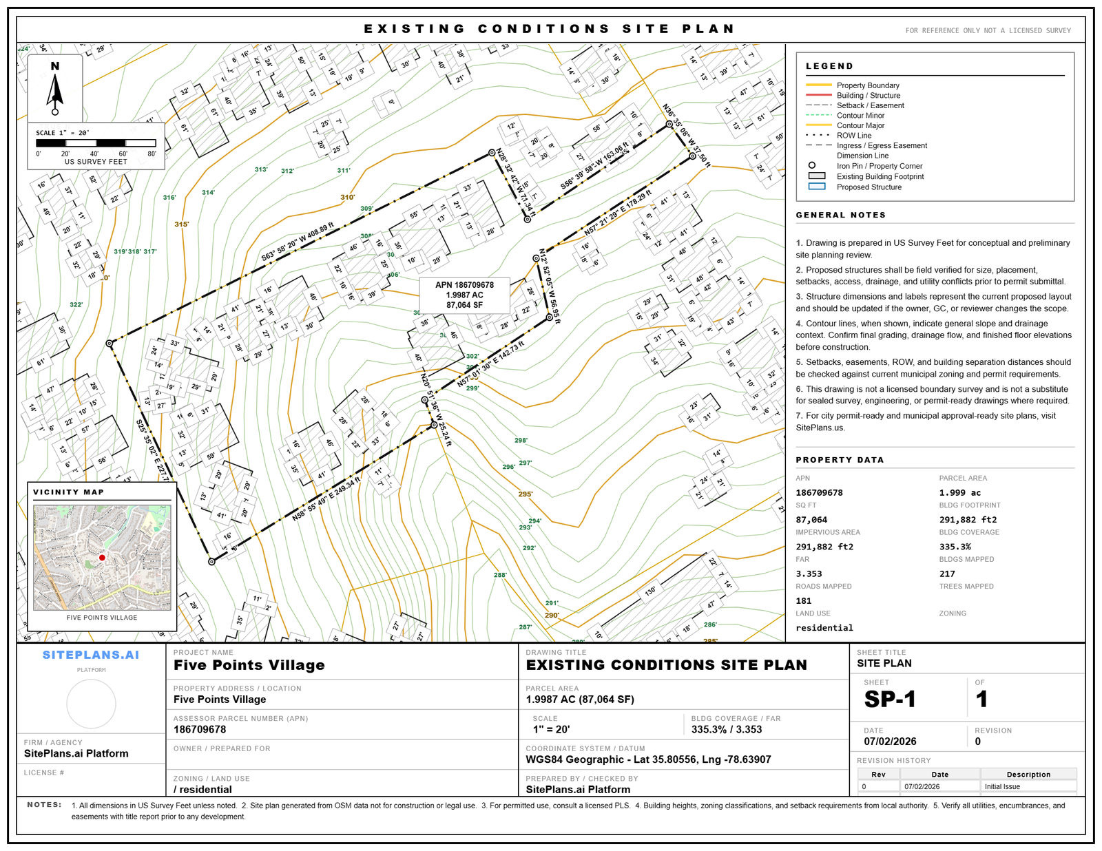
Contour lines show you the shape of your land — where it's flat, where it slopes, and which direction water is likely to flow. Some building departments ask for this on a site plan, especially for sloped lots, floodplain-adjacent properties, or anything involving drainage. Here's how to add them in SitePlans.ai.
Quick Answer
Click Contours in the left toolbar, set your interval (default is 1 ft for minor lines, 5 ft for major lines), and click Generate. The contour lines will appear over your property. You can clear them and try a different interval anytime.
When You'll Actually Need This
Not every permit requires contours, but check for them if:
- Your lot has a noticeable slope
- You're near a floodplain or drainage easement
- Your city's site plan checklist mentions topography or grading
- You're trying to figure out where water will pool or run off before placing a structure
- You're working out the best spot for a deck, shed, or addition on uneven ground
If none of that applies to your project, you can likely skip this step.
Step-by-Step: Generating Contours
1. Enter your property address
Type your address into the search bar at the top of the screen and select the correct parcel.
2. Open the Contours tool
Find the Contours icon in the left toolbar — it looks like stacked contour lines — and click it.
3. Set your interval
A pop-up window gives you two settings:
| Setting | Default | What it controls |
|---|---|---|
| Minor interval | 1 ft | Vertical distance between each contour line |
| Major interval | 5 ft | Every fifth line drawn thicker and labeled |
The defaults work for most residential lots. Only change these if your city specifically asks for a different interval.
4. Click Generate
The contour lines will appear over your property in a few seconds.
5. Review what you're looking at
Lines close together mean steep terrain. Lines spaced further apart mean a gentler slope. Use this to get a feel for how your lot drains before you place anything.
6. Clear and retry if needed
Not happy with the spacing? Click Clear, adjust the interval, and hit Generate again. No harm in experimenting.
7. Keep building your plan
Once the contours look right, go ahead and add your structures, setbacks, and labels. The contour lines stay in place while you work.
8. Export your PDF
When you're done, export as usual — the contour lines will be included in the final drawing.
Before You Export, Check
- The interval matches what your city's checklist asks for, if they specify one
- Contours cover the full property, not just part of it
- The lines look continuous — no odd jumps or gaps
- Your proposed structures make sense relative to the slope shown
- Title block and project details are filled in
Common Mistakes
Using the default interval without checking your city's requirement. Some building departments specify an exact interval. Confirm before you submit.
Not clearing old contours before regenerating. Hit Clear first, or you may end up with overlapping lines.
Placing a structure without looking at the slope first. A flat-looking lot on satellite imagery can still have real grade to it — check the contours before you commit to a layout.
Treating this as a substitute for a survey. It isn't one — see the note below.
If Something's Not Working
No contours appear — Make sure you've selected a parcel first; contours generate based on the property boundary.
Contours look off — Clear and regenerate. If the shape still seems wrong, your area may not have detailed elevation data available yet.
Contours don't cover the whole lot — This depends on the elevation data available for your area. Coverage varies by location.
Map won't load — Refresh the page. If it's still stuck, reach out to support.
A Quick Note on What This Is (and Isn't)
Contour lines in SitePlans.ai are built for planning — getting a practical sense of your lot's slope and drainage before you finalize a layout. They're not a substitute for a licensed surveyor's topographic survey. If your city requires official elevation data, a stamped topo, or you're dealing with floodplain compliance, that's a job for a licensed professional, not this tool.
When to Get Help
Reach out to SitePlans.ai support or use the done-for-you option from SitePlans.us if:
- The contour lines don't look right for your specific property
- You're in a floodplain and need certified elevation data
- Your city requires a licensed surveyor or engineer to sign off on topography
- Your permit was already rejected over a drainage or grading issue
- You want a professional to check the full plan before you submit
Related SitePlans.ai Tools
- Create your site plan from an address
- How to add setbacks to your site plan
- How to export your site plan PDF
- SitePlans.ai support center
FAQ
What are contour lines on a site plan?
Lines connecting points of equal elevation across your property. The closer together they are, the steeper that part of the lot.
Do I need contours for my permit?
Depends on your city. Sloped lots, floodplain-adjacent properties, and drainage-sensitive projects are the most common cases where a building department asks for this. Check your city's checklist to be sure.
What interval should I use?
1 ft minor / 5 ft major works for most residential lots. If your city specifies a different interval, use that instead.
Can I change the interval after generating?
Yes — click Clear, adjust the numbers, and generate again as many times as you need.
Does this replace a surveyor's topographic map?
No. It's useful for planning and layout decisions, but it's not a certified survey. If your jurisdiction requires one, you'll still need a licensed surveyor.
What if my property doesn't show any contours?
Elevation data coverage varies by area. If nothing generates, your location may not have detailed data available yet.
Will the contours show up in my exported PDF?
Yes, they're included automatically when you export your site plan.
What if the city asks me to revise the contours?
Clear and regenerate with a different interval for simple fixes. For anything more involved — or if the rejection was about drainage compliance — the done-for-you option through SitePlans.us is the safer route.
Start Here
Enter your address, generate your contours, and see your property's slope before you place anything on it.
Need a professional to check your grading or drainage?